
 Wyślij jako kartkę
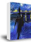
Guadeloupe
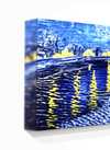
Giclée / Wydruk artystyczny
Druk giclée lub płótno o jakości muzealnej, szybka realizacja i szeroki wybór opcji wykończenia. (![]() Zamów ręcznie malowaną reprodukcję
Zamów ręcznie malowaną reprodukcję![]() Kup obraz wysokiej rozdzielczości)
Kup obraz wysokiej rozdzielczości)
Wybierz spośród naszych standardowych rozmiarów, które zachowują oryginalne proporcje dzieła sztuki.
Możesz wprowadzić własne wymiary, aby dopasować dzieło do konkretnej ramy lub przestrzeni. Jeśli wybrany rozmiar nie będzie odpowiadał proporcjom oryginalnego obrazu, przytniecie dzieło lub rozszerzymy obraz za pomocą odbicia lustrzanego lub jednolitego wypełnienia krawędzi. Przed rozpoczęciem produkcji prześlemy cyfrową wizualizację do Twojej akceptacji.
Prosimy pamiętać, że podgląd na ekranie nie odzwierciedla faktycznego przycinania ani rozszerzania. Tylko wizualizacja dokładnie pokaże końcową kompozycję.
Mimo dostępności niestandardowych rozmiarów, zalecamy wybór wymiaru z listy zdefiniowanej, aby zachować oryginalne proporcje.
Dostawa na cały świat () w ciągu 2 tygodni zamiast standardowych 4/5 tygodni. (22 Sierpień)

Bezpłatna ekspresowa wysyłka na cały świat

Wysokiej jakości płótno lniane

Pełne ubezpieczenie przesyłki

Gwarancja zwrotu należności celnych i podatków importowych

Gwarancja wiernego odwzorowania kolorów

Polityka 60-dniowego zwrotu (tylko w przypadku wad)

Gwarancja 100% zwrotu kosztów

Zniżka przy zamówieniu wielu produktów
 Opcja ze szkłem jest dostępna wyłącznie w rozmiarach poniżej 110 cm

Guadeloupe
Giclée / Wydruk artystyczny
Wymiary reprodukcji
-


Cena całkowita
$ 64
Podobne dzieła


O artyście
A Cartographer of Empire: The World According to Thomas Jeffreys
Thomas Jeffreys, a name perhaps less celebrated than his contemporaries yet pivotal in shaping the visual understanding of the 18th-century world, was born in London in 1719. He entered an era brimming with exploration, colonial ambition, and a burgeoning demand for accurate geographical representation. While details of his early life remain somewhat elusive, it is known that he established himself as a mapmaker and engraver, quickly gaining recognition for the quality and artistry of his work. Jeffreys wasn’t merely copying existing charts; he synthesized information from diverse sources – travelers' accounts, official surveys, and previous cartographic endeavors – to create maps that were both informative and aesthetically compelling. He operated in an age where mapmaking was a complex blend of scientific endeavor, artistic skill, and political projection, and Jeffreys navigated this landscape with considerable acumen. His career flourished during the reigns of George I and George II, periods marked by significant British expansion and increasing global trade.The Art of Depiction: Style and Influences
Jeffreys’ maps are immediately recognizable for their distinctive style. He favored a richly ornamented aesthetic, incorporating elaborate cartouches, detailed depictions of flora and fauna, and often, allegorical figures representing the regions portrayed. This wasn't simply decorative flourish; it reflected the prevailing taste for visual grandeur and served to emphasize the wealth and power associated with the territories depicted. His work stands apart from the more austere, mathematically focused maps produced by some of his contemporaries. He blended scientific accuracy with artistic license, creating images that were both useful navigational tools and compelling works of art. Influences on Jeffreys’ style can be traced to earlier cartographic traditions, particularly those of Dutch mapmakers like Johannes Blaeu and Frederick de Wit, renowned for their detailed and decorative maps of the East Indies and Americas. However, Jeffreys infused his work with a distinctly British sensibility, emphasizing the role of British exploration and commerce in shaping the global landscape. He also drew inspiration from contemporary architectural designs and ornamental patterns, evident in the intricate borders and cartouches that frame his maps.Charting New Worlds: Major Works and Achievements
Jeffreys’ most significant achievement lies in his ambitious project to create a comprehensive atlas of the world. The Complete Illustration of Universal Geography, published in installments between 1744 and 1761, became one of the most influential atlases of its time. It wasn't simply a compilation of existing maps; Jeffreys meticulously revised and updated each chart, incorporating new discoveries and correcting inaccuracies. The atlas was particularly notable for its detailed depictions of North America, reflecting the growing British presence in the region. His map of Virginia, for example, provided valuable information about the colony’s geography, resources, and Native American settlements. Beyond his atlas, Jeffreys produced a series of highly sought-after individual maps focusing on specific regions, including Europe, Asia, Africa, and the West Indies. He also published several volumes of illustrated geographies, aimed at educating a wider audience about the world beyond their shores. His work wasn’t limited to large-scale atlases; he created smaller, more portable maps for travelers and merchants, demonstrating his versatility as a cartographer.A Legacy in Lines: Historical Significance
Thomas Jeffreys' contribution extends far beyond the aesthetic beauty of his maps. He played a crucial role in shaping public perception of distant lands during an era of intense colonial competition. His detailed depictions of North America, for instance, helped to fuel British expansion and solidify its claims to territory. His maps weren’t neutral representations of geography; they were imbued with political and economic agendas, subtly promoting the benefits of British trade and colonization. The accuracy and detail of his work made them invaluable resources for explorers, merchants, and policymakers alike. Even today, Jeffreys' maps remain highly prized by collectors and historians as important primary sources for understanding the 18th-century world. They offer a fascinating glimpse into the geographical knowledge – and biases – of the period, revealing how Europeans perceived and represented distant cultures and landscapes. His legacy lies not only in his artistic skill but also in his ability to translate complex information into visually compelling narratives that shaped the course of history. Jeffreys’ maps continue to resonate as testaments to a time when cartography was both an art form and a powerful tool of empire.
thomas jefferys
1719 - 1771
Krótka nota
- Artistic Movement Or Style: Early Enlightenment
- Artists Or Movements Influenced By This Artist: ['Andrew Dury']
- Artists Who Influenced This Artist:
- Charles Price
- John Seller
- Date Of Death: 1771
- Full Name: Thomas Jefferys
- Nationality: British
- Notable Artworks:
- The Russian Discoveries
- A Plan of all the Houses, destroyed & damaged by the Great Fire
- Place Of Birth: London, England

